Vegetation Change Monitoring along Boundary Areas of Everglades National Park
Funding Agency: Everglades National Park
People: Daniel Gann, PI / Jennifer Richards, Co-PI / Brittany Harris/ Jed Redwine, Everglades National Park Representative
Project Objective
The primary objectives of this project are (1) to map species composition/vegetation patterns and their changes along the northern and eastern boundary of Everglades National Park (ENP) at a minimum mapping unit between 16-100 m2 using remote sensing methods; and (2) to estimate the total biomass of dominant species vegetation classes and changes in biomass patterns over time.
Historically, the Shark River Slough (SRS) was a major flow-way from the northern into the southern Everglades. Construction of the east-west Tamiami Trail, followed by north-south canal and levee construction, has greatly reduced and channeled this historical flow to Everglades National Park. A 1-mile bridge and road-raising along the Tamiami Trail, which allows water to flow under the bridge and enable additional water deliveries to ENP, was completed in December, 2012. This ModWaters/CERP monitoring project is a continuation and extension of two previous monitoring efforts, one from 2006-2009 and the second from 2012-2013. Data are being collected on hydrology, water quality, floc and soil nutrients, periphyton type, frequency, biomass and TP, aquatic consumers (fish and macroinvertebrates), vegetation nutrients, and vegetation abundance and distribution. The data collected over the duration of this project, combined with data from future monitoring projects following CERP implementation projects, will allow the NPS to answer management questions focused on how MWD/CERP implementation affects ecological indicators throughout the northern and eastern boundary of ENP.
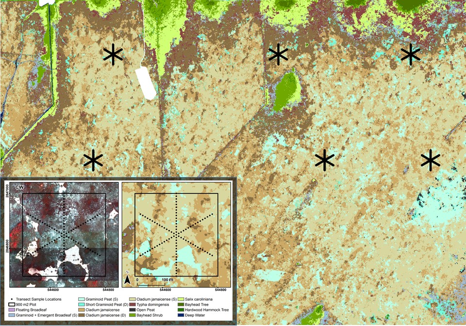
Vegetation Change Monitoring
To determine compositional, structural and biomass changes in vegetation along the northern and eastern boundary areas of ENP, we are using bi-seasonal WorldView-2 and -3 satellite data (as available) in combination with airborne LiDAR data to map vegetation communities in Western Shark River Slough (WSRS), North Eastern Shark River Slough (NESRS) and in Upper Taylor Slough (UTS). These vegetation maps provide a landscape context for interpreting biotic, abiotic and biogeochemical data collected by other research groups. In addition to exhaustive mapping of vegetation trends, we are monitoring vegetation changes along several transects that are arranged in star formation at multiple sites within the three monitoring areas. These transects provide more detailed data on vegetation composition at finer scales and provide valuable ground reference information for the mapping component.
Date
October 7, 2017
Category
Ecosystems