Remote Sensing Supported Vegetation Detection in the Hole-in-the-Donut Restoration Areas
Project Link: Synthesis Report (http://digitalcommons.fiu.edu/gis/24/)
Funding Agency: Everglades National Park
People: Daniel Gann, PI / Himadri Biswas, Research Associate / Evan Cook, Research Associate / Jonathan Taylor, Everglades National Park Representative
Evaluation of restoration success can consist of multiple metrics and indices. Some of the metrics, e.g., species diversity and ratios of native vs. exotic species, can be derived from extensive field surveys. Estimation and spatial analysis of vegetation cover and abundance require spatially explicit vegetation maps with adequate spatial and thematic resolutions and precision in order to determine restoration success.
Remotely sensed data sets are spatially explicit and exhaustive data sources that allow for mapping the full extent of vegetation at high spatial resolutions. Depending on the spectral and radiometric characteristics of the sensor used, vegetation classes can be differentiated based on their electromagnetic reflectance properties. To successfully apply remotely sensed data, two major challenges must be addressed: (1) defining a vegetation classification system and associated metrics that allow for evaluation of restoration or vegetation succession; and (2) understanding the variability in spectral response signatures associated with each class in an environment of seasonal and inter-annual fluctuations in water levels and phenological cycles of the vegetation.
Spectral, radiometric, and spatial resolutions of remotely sensed data are critical in detecting vegetation types and vegetation change based on differences in spectral reflectance properties. Choice of a remote sensor with suitable spectral characteristics to distinguish vegetation classes limits the options for spatial and temporal resolution. To evaluate the suitability of remote sensing data sets and methods when assessing restoration efforts, data and methods need to be evaluated in the context of specific boundaries of vegetation in a clearly defined classification system. Development of a vegetation classification system suitable for remote sensing applications is critical. The classification system needs to represent all classes of vegetation patterns and surface conditions that are present at the time when a remote sensor acquires the data. Spectral reflectance patterns of a remotely sensed image grid cell are the integrated response of all vegetation present and, in the case of less than full canopy cover, the substrate makeup and condition. Remotely sensed reflectance patterns capture vegetation co-occurrence patterns. The larger the focus area of detection (i.e., spatial resolution), the more mixed the vegetation and substrate conditions are expected to be.
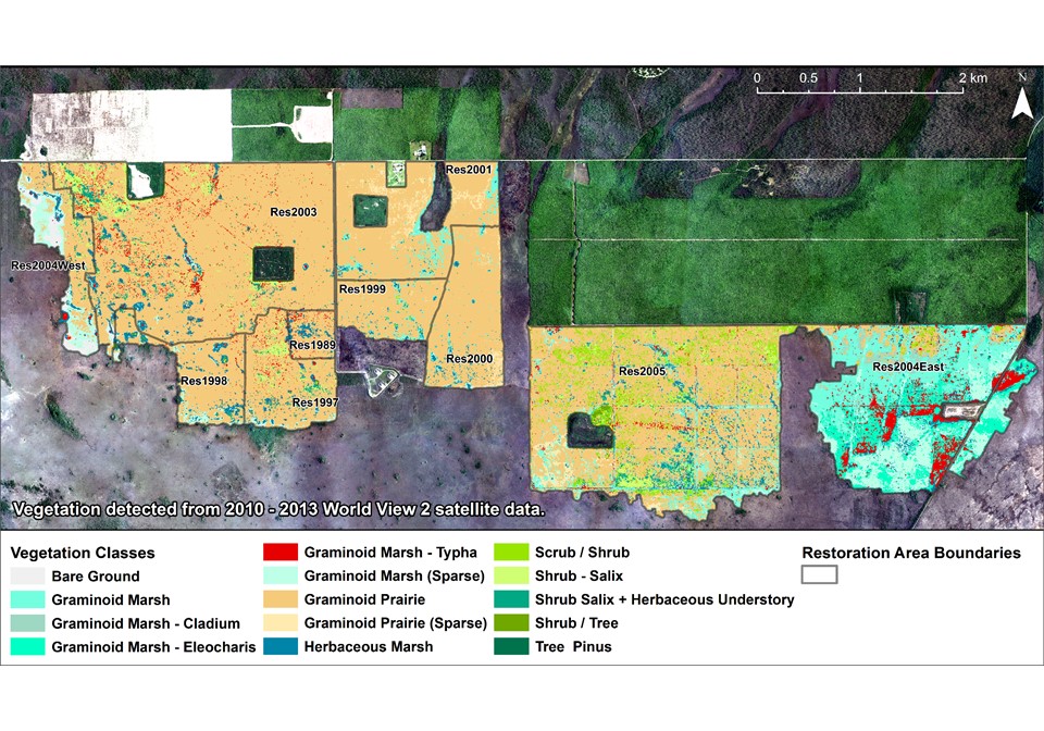
This project sought to establish a method to integrate and build on existing detailed vegetation surveys conducted on 100-m2 plots in the Hole-in-the-Donut restoration area, Everglades National Park, USA. Characterization of vegetation in survey plots is crucial to understanding variability in species composition at specified scales of interest. The limitations of basing a classification system on surveys alone are the limited sample size and the associated non-exhaustive class representation. Small sample sizes will not guarantee the full range of variability for each vegetation type; mapping vegetation across larger heterogeneous landscapes requires generalization in the form of a hierarchical or non-hierarchical classification system. A hierarchical system allows for scaling of classes by collapsing classes of lower hierarchical level into a higher level, whereas a non-hierarchical system does not assume a many-to-one relationship across different levels or scales. For instance, at a specified spatial resolution, a species can occur as monotypic stands, but this species can also occur interspersed with other species across multiple, coarser spatial scales. The same species would thus be aggregated into more than one hierarchical level. This many-to-many relationship cannot be easily integrated into existing hierarchical classification systems. For example, Typha and Salix can occur both in shorter hydroperiod prairie environments and in longer hydroperiod marsh environments. Thus, Salix, Typha, and mixed Salix/Typha classes cannot be aggregated to a single higher-level prairie or marsh.
Date
January 2, 2011
Category
Ecosystems