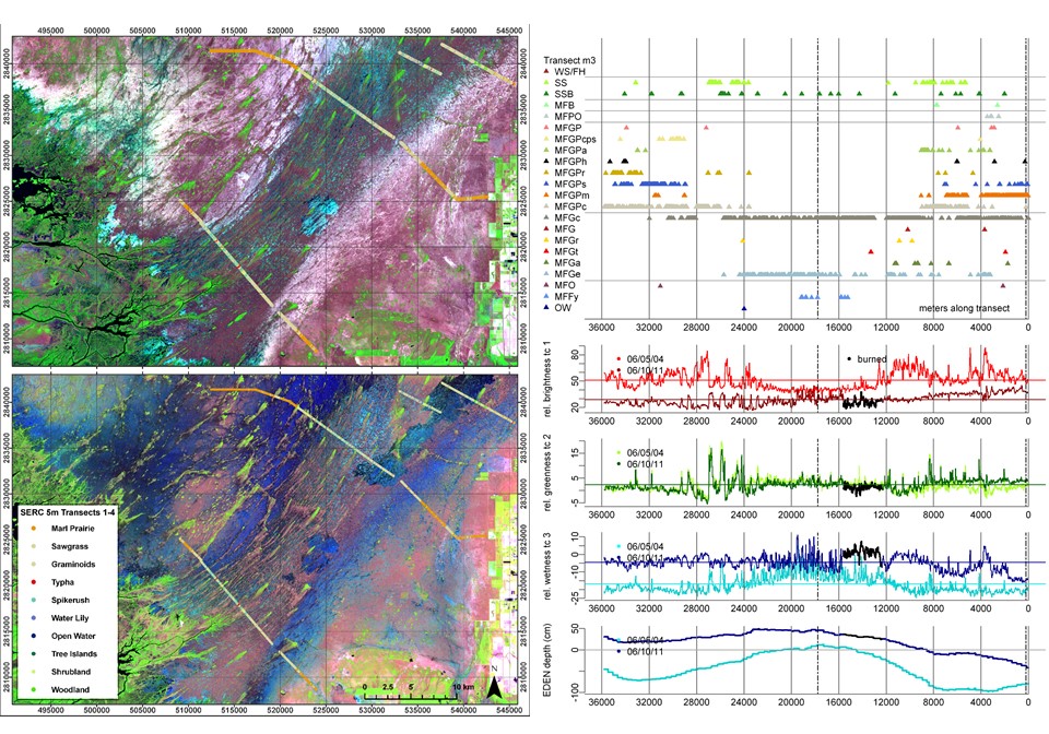
Plant Community Classification from Satellite Imagery for the Greater Everglades Freshwater Wetlands & Community Abundance, Distribution and Hydroperiod Analysis
Project Link: Synthesis Report (http://digitalcommons.fiu.edu/gis/23/)
Funding Agency: South Florida Water Management District
People: Daniel Gann, PI / Jennifer H. Richards, Co-PI / Andrew Gottlieb, SFWMD Representative
The four main objectives of this research project were:
- To develop methods for using satellite imagery to differentiate and map plant communities in WCA 2A from remotely sensed imagery, and to test the effectiveness of those methods.
- To develop methods for using satellite imagery to differentiate marl prairie communities from ridge/slough/tree island communities in Everglades National Park.
- To compare the WCA 2A map developed from remote sensing to extant maps of WCA 2A, then to develop estimates of plant community hydrologic requirements by spatial correlations of the EDEN hydrologic record with plant community data.
- To compare the EDEN hydrologic record with hydrology predicted by the SFWMD Natural System Model (NSM), and to predict how plant community distribution would change under NSM. A consistent theme in this research was the issue of scaling, either scaling fine-scale, field-collected data on plant communities to medium resolution satellite imagery, or scaling plant community data or hydrologic data to larger landscape units, such as a 2×2 mi grid or indicator regions.
We have developed a variety of methods to accomplish this scaling for our different objectives.
Date
January 16, 2010
Category
Ecosystems