Endangered Colonial Waterbirds · 2010–2024
Counting What We Cannot Afford to Lose
AI-powered monitoring of endangered colonial waterbirds across 14 years of Biscayne National Park.
Published Dataset Open Access
AI-powered monitoring of endangered colonial waterbirds across 14 years of Biscayne National Park.
Published Dataset Open AccessEvery survey flight, every nest annotation, every colony — mapped and tracked from 2010 to 2024. Hover the chart, click the map, then dive into the full dataset below.
Annotations, detections, and flights across 14 survey years — spot colony booms, crashes, and gaps at a glance.
Seven colony sites across Biscayne National Park — every dot is a nest count waiting to be studied.
Traditional monitoring of coastal waterbirds in remote park areas is labor-intensive and prone to error. Our AI framework automates this process using sub-meter resolution aerial imagery spanning 15 years of Biscayne National Park colonial surveys.
Tap a card to reveal the numbers
7 of 9 colony monitoring sites mapped in Biscayne National Park (2 sites pending GPS coordinates). Click a marker for site details.
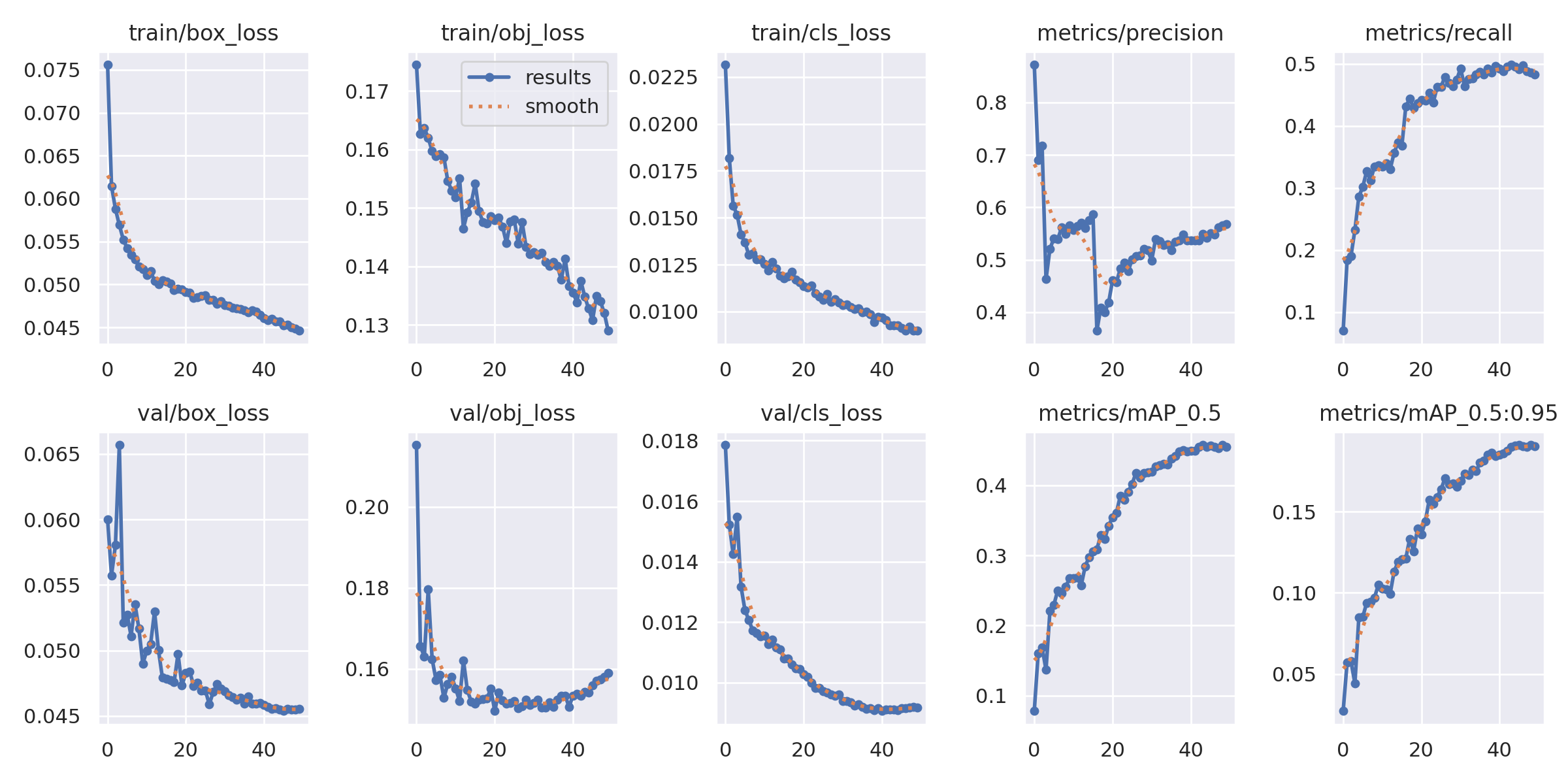
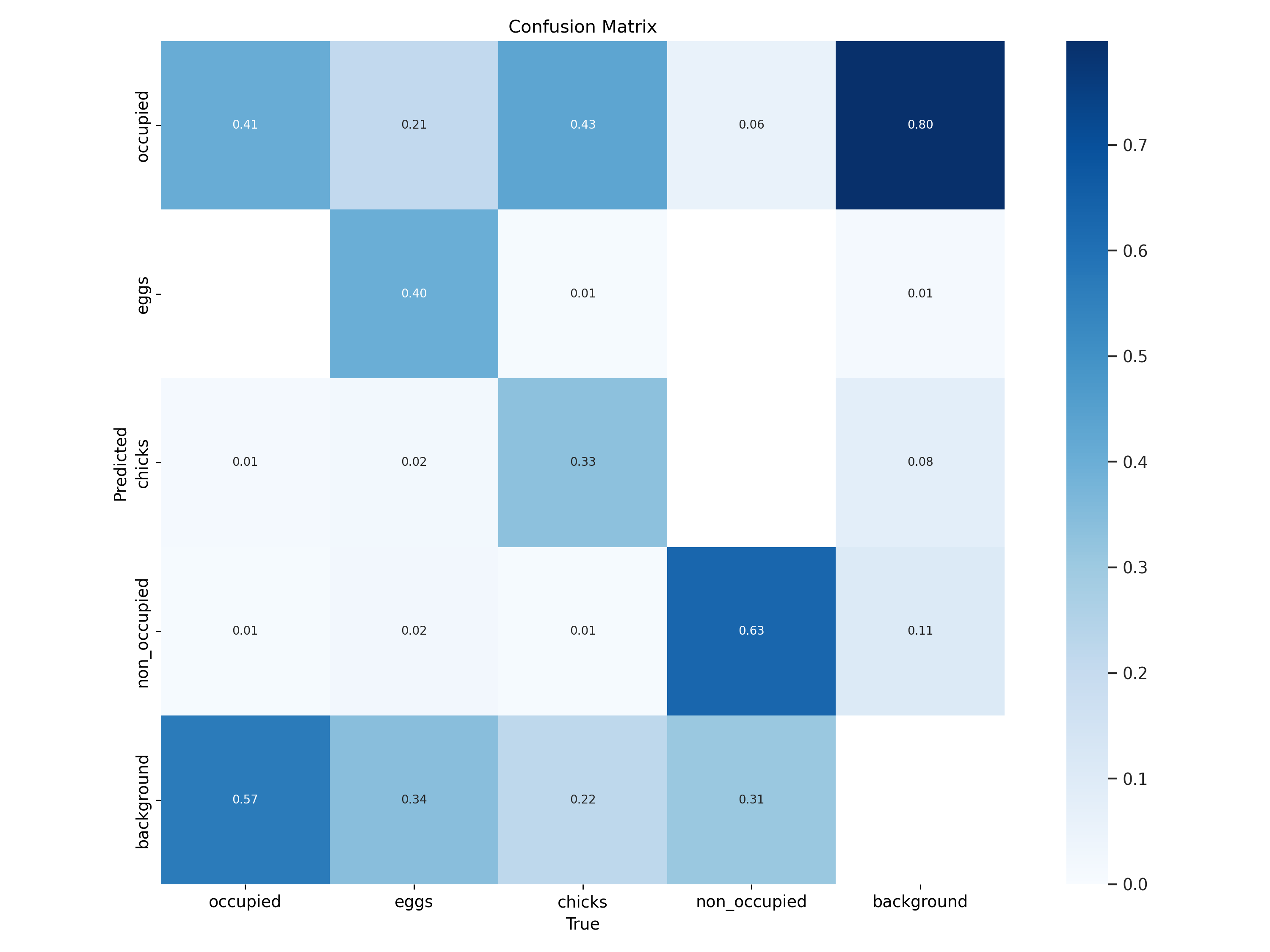
YOLOv5s6 trained on 15,759 aerial images achieves mAP@0.5 = 0.458 on the held-out test set, enabling rapid, consistent nest detection across island colonies.
Upload an aerial photograph to run the YOLOv5s6 nest detection model in real time. Achieves mAP@0.5 = 0.458 · 4 classes · 1280 px inference size.
Join the National Park Service and scientific community in refining the models that protect our avian neighbors. Access open-source datasets or deploy detection tools in your own research.
Access our Python-based detection SDK and datasets. Download the full 113 GB image archive, 161,744 YOLO annotations, trained weights, and training notebooks.
View real-time nest detection maps and impact reports. Use our live inference demo to run detection on your own aerial imagery. Dataset is in the public domain — free to download, use, and share.
Public domain under 17 U.S.C. § 105 — US federal government works. No license required.
Public Map → Live DemoAPA
BibTeX
@dataset{juhasz_guan_2025_birdnest,
  author    = {Juhasz, Levente and Guan, Boyuan},
  title     = {Colonial Bird Nest Detection Dataset:
               Biscayne National Park Aerial Monitoring 2010--2024},
  year      = {2025},
  publisher = {Florida International University GIS Center},
  doi       = {10.34703/gzx1-9v95/UD9HTD},
  url       = {https://dataverse.fiu.edu/dataset.xhtml?
               persistentId=doi:10.34703/gzx1-9v95/UD9HTD}
}
For questions about the data, contact Dr. Kevin Whelan (NPS) — kevin_r_whelan@nps.gov | Dr. Levente Juhasz (PI) — ljuhasz@fiu.edu