Evaluation of WorldView-2 and Landsat Data to Differentiate and Map Freshwater Marsh Plant Communities at Different Spatial Scales for Two Everglades Landscapes
Project Link: Synthesis Report (http://digitalcommons.fiu.edu/gis/22/)
Funding Agency: South Florida Water Management District
People: Daniel Gann, PI / Jennifer H. Richards, Co-PI / Himadri Biswas, Research Associate / Andrew Gottlieb, SFWMD Representative
The purpose of this project was to evaluate the use of remote sensing 1) to detect and map Everglades wetland plant communities at different scales; and 2) to compare map products delineated and resampled at various scales, with the intent to quantify and describe the quantitative and qualitative differences between such products. We evaluated data provided by Digital Globe’s WorldView 2 (WV2) sensor, with a spatial resolution of 2m, and data from Landsat’s Thematic and Enhanced Thematic Mapper (TM and ETM+) sensors, with a spatial resolution of 30m. We were also interested in the comparability and scalability of products derived from these data sources. The adequacy of each data set to map wetland plant communities was evaluated utilizing two metrics: 1) model-based accuracy estimates of the classification procedures; and 2) design-based post-classification accuracy estimates of derived maps. The following four questions guided this research:
- What is the overall and class-specific detection accuracy for Greater Everglades freshwater marsh plant communities from medium spectral and high spatial resolution (i.e., World View 2) and from medium spectral and medium spatial resolution (i.e., Landsat) satellite data?
- How do overall and class-specific classification accuracies differ at different thematic hierarchical levels (i.e., detection at the plant community level vs. structural level) and different spatial resolutions (i.e., WV2 vs. Landsat and WV2 aggregated to Landsat spatial resolution)?
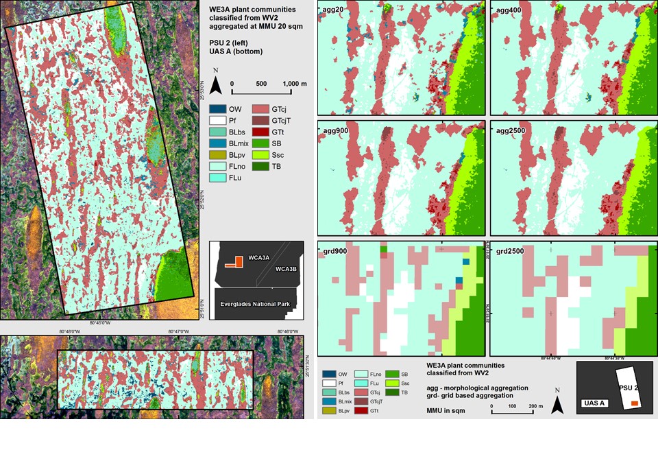
- How do aggregation algorithms applied to high spatial resolution (detection) maps compare when aggregating to medium resolution maps using a morphological aggregation algorithm versus grid-based (arbitrary origin) majority rules? For the purpose of this project we were interested in two resolutions: 1) 30x30m, the pixel size of Landsat data; and 2) 50x50m, the grid cell size of visually interpreted vegetation maps provided by CERP 2004/2009.
- How does the heterogeneity of grid-based maps aggregated by a simple majority rule compare to that of maps classified at the same grid-based resolution?
Date
January 16, 2011
Category
Ecosystems