Enhancing suitability analysis of potential living shoreline locations to optimize resilience to sea level rise
Project Name: Enhancing suitability analysis of potential living shoreline locations to optimize resilience to sea level rise
Project Link: https://futureshorelines.fiu.edu
Funding Agency: Environmental Protection Agency
People: Randall Parkinson (FIU Institute of Environment, PI), Levente Juhasz (Co-PI), Jennifer Fu (Co-PI), Julian Gottlieb, Jinwen Xu
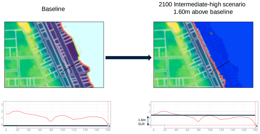
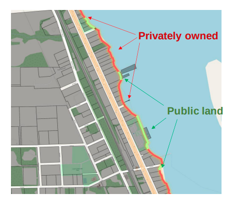
We propose to expand upon existing geo-spatial web frameworks and related guidelines often used to site living shoreline installations by integrating an additional suite of parameters designed to optimize resilience to sea level rise (SLR). These include current land use, parcel ownership and value, future SLR inundation elevations corresponding to three regionally relevant scenarios (intermediate-low, intermediate, intermediate-high, high) for years 2030, 2040, 2050, and 2100
Deliverable
On-the-fly visualizations containing dynamic maps, infographics, charts, and summary statistics will be instantly generated once the user selects (1) a geographical area, (2) attributes of interest and (3) SLR scenario. This output will benefit local coastal resource managers by providing a novel approach to site selection that optimizes installation resilience and its potential to mitigate future losses of coastal wetland habitat, water quality degradation, and coastal erosion.
Date
October 26, 2022
Category
Climate Change, Ecosystems, Human-environment Interaction, Sea Level Rise